Geographical data can reveal a lot about a patient’s state of health.
Jun 24, 2016
Read the latest GeoCoLaus (CHUV, HUG, EPFL) article here. This article was nominated as one of the Best Swiss Article of the Year 2015.
Bill Davenhall's TED
When Bill Davenhall turned 55, he began to suffer from heart problems. Even though he knew he was genetically predisposed to develop the condition, he wanted to know what had triggered the onset of the disease.
“I decided to analyse the places where I’d lived,” he says. He spent the first nineteen years of his youth in a rural area in Pennsylvania, where natural gas extraction was common. “There, I breathed high concentrations of carbon dioxide and methane gas.” Then he moved to Louisiana, settling in a city next to a plastic plant. “I spent twenty-five years there breathing chloride and benzene.”
A few years later, he moved to Los Angeles. “It’s an area with high doses of ozone and carbon dioxide,” he says. When you look at the geographical breakdown of people with cardiovascular problems, “if I wanted to have a heart attack, I’ve been to the right places.”
That realisation turned his life upside down. “Would I have chosen to live in those places if I’d known previously that I was increasing my chances of developing a heart condition? Definitely not.”
The My Place History smartphone app, presented at a TEDMED conference in 2009, can be used by Americans to enter the different places they have lived in their life. They can then cross their “itinerary” with government databases such as the “Toxics Release Inventory”, which lists the toxic chemicals that they could have, or can, come into contact with in those areas.
Today, Bill Davenhall devotes himself to promoting the use of geographical data in medicine, which is called geomedicine. “This information is just as important as my genetic predisposition or my lifestyle,” he says. “But no doctor has ever asked me questions about where I live.”
He advocates including information on place history into patients’ health records. “The doctor could then know whether a person has been exposed to chemicals or toxic gases,” he says. “And the diagnosis would be more accurate.”
Obesity in Geneva
A growing number of people are turning to geomedicine today in 2014, even though the field of study has been around for some time. Back in 1853, epidemiologist John Snow used a map of cholera cases and water wells in London’s Soho district to track down the source of an outbreak.
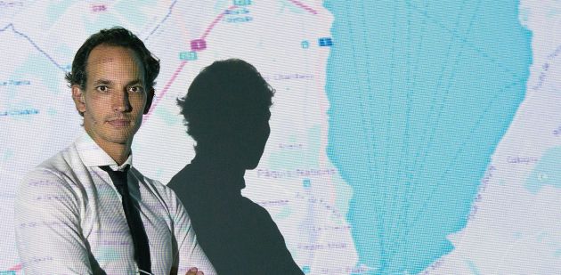
Idris Guessous, an epidemiologist who works for Lausanne University Hospital and Geneva University Hospitals, applies the same method. He published a report in March 2014 on obesity in the canton of Geneva.
“We observed where overweight people are located in the canton to check whether there was any spatial clustering,” the physician says. He came to some interesting conclusions. The researcher discovered a clustering of people with the same weight on the left bank. People on that side were thinner than those on the right bank.
Idris Guessous offers three explanations for this pattern. First, there is more fast food on the right bank in the canton, providing easier access to fattening food. However, sport facilities are more developed on the left bank. It is therefore easier to exercise. “The third reason is sociological,” the researcher says. “We discovered a group effect. When people live together, they tend to adopt similar behavioural patterns, which drives them to have the same weight.” He is currently studying the exact reasons for this phenomenon.
His discoveries are highly valuable and could be used to develop new strategies in the fight against obesity. “The maps we have designed can be used by the government to determine where to build sport facilities and launch prevention campaigns,” the expert says. Eventually, once the mechanism is established that drives the population living in certain areas to stay thinner, it will be a question of “transposing the healthy habits of these areas to others,” he concludes.
Technological boom
The recent development of geomedicine is mainly a result of new technologies. “It’s much easier than it used to be to collect data,” says Idris Guessous. “There is more of it, and we have software to process data rapidly. We can send a helicopter over the Geneva area to collect hundreds of thousands of data. We can also calculate the pollution rate down to the minute, which used to be unimaginable.”
The miniaturisation of electronic devices (GPS, drones, etc.) and development of smartphones have transformed the field. Marcel Salathé, a Swiss researcher at Penn State University in the United States, has created crowdbreaks.com, a website that tracks disease trends.
“We take our information from Twitter to detect where certain conditions are developing in real time,” he says. “The system helps us to locate them geographically.” Google has also developed Google Flu, which aggregates online search data to identify regions with flu activity. When the words “headache” or “cold” are frequently entered in the search engine, it indicates a household with a case of flu.
“Would I have chosen to live in those places if I’d known previously that I was increasing my chances of developing a heart condition? Definitely not.”
The British physician John Snow (1813-1858) is considered the founder of epidemiology. He studied the cholera epidemic that swept through London in 1854. By mapping out the mortality rate in different areas of the city, the epidemiologist concluded that the source of the Soho outbreak was sewage-polluted water coming from the Broad Street pump.
These new technologies have also given rise to gadgets used to improve treatment based on geomedicine. Bill Davenhall has developed a smartphone app called My Place History. Users enter their home location to assess the health risks associated with that area. David Van Sickle, anthropologist and founder of the start-up Propeller Health, has come out with an asthma inhaler embedded with a GPS tracker to indicate where his patients are using the device. “This shows us which environments bring about asthma attacks,” he says. “We can then tell our patients to avoid going places where they know that the atmosphere will give them problems.”
Or simply understand how the disease works. “We discovered in a study conducted in Wisconsin that people
in rural areas used their inhalers more often than people in the city, which contradicts current studies.” The prevailing hypothesis is that asthma is caused by pollution.
But this geographical information also poses a serious threat to personal data protection. What will happen if companies get their hands on our geomedical record? Could an insurance company charge a customer higher premiums based on their geographical history? “We have to be very careful with the use of this type of data,” says David van Sickle. “Patients have to be able to check the information that they disclose. It’s crucial.” Bill Davenhall is more optimistic: “Geomedicine will considerably improve our treatment. It’s worth taking that risk.”
"We’re surrounded by millions of toxic substances”
A recent report from a Harvard University research team warned that new chemicals that can affect our nervous system have been identified. Analysis from Nathalie Chèvre, ecotoxicologist at the University of Lausanne (UNIL).
IV What new findings are in this report for neurotoxin product research?
Nathalie Chèvre Interest in pollutants dates back to the 1920s, and they were already discussed in reports by the 1950s. However, this study says that the substances listed have been proved and recognised to affect the human nervous system. Research estimates that nearly 100,000 chemicals on the market can be found in our environment. And each one can create other compounds, which break down once released in the environment and create other potentially toxic molecules.
IV How much exposure do we have to these substances?
NC The study named manganese, fluoride, the pesticide chlorpyrifos, lead and polybrominated diphenyl ethers [or PBDEs, used as flame retardants]. And they’re all over the place! In dust, sediment, food, textiles, etc. These chemicals could affect health after long-term exposure to low doses.
IV What is their impact on children?
NC Of the chemicals listed, the effects of chlorpyrifos are well known. This molecule over-stimulates the nervous system and disrupts behaviour in both adults and children. In fact, children are the most susceptible as their nervous system is still being formed. They can develop serious neurological disorders such as hyperactivity. There is no miracle solution to protect yourself against chemicals, but washing clothes before wearing them for the first time and eating organic or locally-grown food are first steps. Comparatively, we are rather lucky in Switzerland was we have many relevant standards and regulations that are already in force.